Difference between revisions of "Maps"
Jump to navigation
Jump to search
| Line 1: | Line 1: | ||
[[Category:Maps]] [[Category:Geography]] | [[Category:Maps]] [[Category:Geography]] | ||
| − | |||
| − | |||
| − | |||
| − | |||
| − | |||
| − | |||
| − | |||
| − | |||
| − | |||
| − | |||
| − | |||
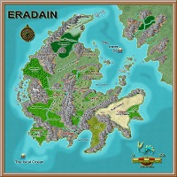
[[File:Eradain_Prime_4.9thumb.jpg |link=Map Eradain|thumb|left|Continent]] | [[File:Eradain_Prime_4.9thumb.jpg |link=Map Eradain|thumb|left|Continent]] | ||
| Line 19: | Line 8: | ||
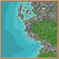
[[File:RhanFionn (800x799).jpg | link= RhanFionn (800x799).jpg | 200px | thumb | left | Region 9 - Rhan Fionn/Ceirin]] | [[File:RhanFionn (800x799).jpg | link= RhanFionn (800x799).jpg | 200px | thumb | left | Region 9 - Rhan Fionn/Ceirin]] | ||
| + | |||
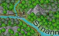
| + | [[File:Templeton.jpg | thumb | left |Map of Templeton - Sun Temple of Lugh]] | ||
.jpg)

.jpg)