Topography
Contents
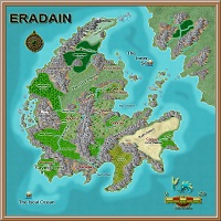
Eradain
Please note that certain descriptions are based on a particular time period in Eradain. They may or may not be applicable or accurate for other time periods.
Astronomical Data
The Eradain Year extends 364 days, consisting of twelve months each having four seven-day weeks, plus an additional "month" made of the four festival weeks. The festival weeks are the Solstices (Yule and Litha), and the Equinoxes (Ostara and Mabon). Eradain has two moons. The smaller moon Celene goes through four cycles, becoming full on the middle evening of each of the festivals. Luna, the larger moon, makes thirteen cycles of twenty-eight days during a year. The months named in order are: Fireseek, Readying, Coldeven, Planting, Flocktime, Wealsun, Reaping, Good-Month, Harvester, Patchwall, Ready'reat and Sunsebb.[1]
Geography
The continent of Eradain is located in the Northern Hemisphere of planet Arden in the Iscal Ocean, separated from the Tolmak mainland by the Inner Sea. Eradain is crescent shaped and approximately 1000 miles at its longest point and approximately 1200 miles at its widest point, which is roughly twice the size of England and Ireland combined.

The western side of the continent is higher in elevation than the rest of the continent making Eradain generally cooler than other regions of the continent. Due to the bowl shape of the surrounding mountains all Eradain rivers flow through the central valley regions eventually joining together at Lake Erada.
Climate
Eradain weather is relatively mild, spring rain and fog, warm to hot summers, fall fog and some rain, followed by winter fog and snow during Sunsebb and Fireseek. A typical Eradain fog burns off quickly in the lowland and lingers in the forests and highlands. Occasionally the whole land is wreathed in heavy fog for days at a time.
Eradain is a temperate land with long harsh winters in the north, and long hot summers in the southern regions. There is abundant rainfall from the Iscal Ocean blowing in on the western winds, but successive mountain ranges prevent much of this moisture from reaching the desert regions at the southeastern edge of the continent. The Eradain rivers do occasionally flood and even change course, but most near-river cities and villages are built upon hills. Well designed levees in critical places also protect some flood plain farmlands. Fog is common in the coastal areas, the large forests of the west and the western side of the Dagalethe Mountains.
Topography
Three primary ranges of mountains split the continent. Along the western coast are the Djolinder Mountains in the north, the Ostorath Mountains in the center, the Jagged Peaks and the Echoriath Mountains in the south. Splitting the center of the continent are the Dagalethe Mountains. The Dagalethe Mountains have only a few passes that allow east-west travel, most notable is through the city Erada along the Sar River and Daga Pass further to the south. Finally, separating the southeastern portion of the continent are the Barrier Mountains.
The western side of Eradain is heavily forested. The Great Northern Wood consists of evergreen trees and is inhabited by tribes of Wood Elves. The Dwimorlorn Forest is located on the northwestern portion of the continent, and as its name implies it is a dark and twisted forest. The great Dellis trees of the Dwimorlorn leave vast areas of the forest floor in perpetual darkness and it is inhabited by many races of humanoids, giant spiders and other strange creatures. Rumors persist of large ruins located in the depths of the forest. Further south are the Diminar, the Dathi and the Arandil forests. These lands have been forested and traveled by humans for centuries but are not yet fully explored except perhaps by the druids who watch over these lands carefully. Surrounded by the Echoriath Mountains is the Avanoel Forest. This forest is the home of most of the elves on Eradain, and the elves have cultivated many groves of the giant trees they build their famed villages in. The last of the large forests is Thorn-Wood. This forest is so named because of the Dagger Thorn plant which grows there. The Dagger Thorn plant grows very thickly, intertwining about itself and has thorns up to 4' in length. These thorns have a sap that causes a minor allergic reaction in most humanoid creatures when a thorn punctures the skin. A large section of the Thorn-Wood is inhabited by Halflings who ward their borders with great barriers of the Dagger Thorn plant. In the far east is the Kerrich forest, which is actually a narrow region of tough oak trees growing along the Gena River. In the middle of the continent next to the Bay of Serin and the Veran River is the Green Wood, which once covered much of lands east of the Dagalethe Mountains. The Green Wood is the tamest of the forests on Eradain and its well-worn paths are patrolled by foresters to prevent poaching of the nobility's deer. The last forest is Kaylin surrounding the Kalan River located between the Dagalethe Mountains and the Kali Sur Plains. This forest is the second tamest and has been reduced over the centuries due to lumbering by humans and the dwarves of Khuzdul.
On the southern corner of the continent is the Rathi Desert. The Rathi is a dark desert, filled with volcanic ash from Mount Thunder. This volcanic peak continually smolders and ash drifts out chocking the land and covering the land in perpetual gloom. Something in the ash or the land itself causes it to stay barren. There is known to be ruins out in this dark wasteland as well as other dangers that dislike the light. (OLD TEXT - This desert is the result of little rainfall making it over the Barrier Mountains and ash that blows from Mount Thunder, a large and somewhat active volcano. Large portions of the Rathi Desert are composed of sand made of tiny white volcanic crystals which reflect and multiply the sunlight).
South of Mount Thunder is a large grassland called the Bregan Savannah, and is the home of many wild herd animals fierce tribes of human Corsani and Wemic (lion-centaurs).
There are several large rivers, most notable are the Sinann and Saine which combine at Lake Erada and cut through the Dagalethe Mountains as the mighty River Sar. The lands surrounding the Sar are some of the richest farmlands on the continent. The Sar empties into the Bay of Serin, which is part of the Inner Sea The northern portion of the continent holds the Kah-Sur Plains, another area of grasslands on which some of the best horses on the continent are bred by the nomad barbarian Khorharad. At the northern tip of Eradain is the Kar-Tan Wastes. This region has some of the worst weather and toughest ground on the continent and is primarily inhabited by Goblinoids.
The western side of the continent is higher in elevation than the rest of the continent making Angtiria generally cooler than other regions of the continent. Due to the bowl shape of the surrounding mountains all Angtiria rivers flow through the central valley regions eventually joining together at Lake Erada. Adequate rainfall blows in from the Iscal Ocean from the west and irrigation techniques are adequate in dryer years. The Eradain rivers do occasionally flood and even change course, but most near-river cities and villages are built on hills. Well designed levees in critical places also protect some flood plain farmlands. Eradain weather is relatively mild, spring rain and fog, warm to hot summers, fall fog and some rain, followed by winter fog and snow during Sunsebb and Fireseek. A typical Eradain fog burns off quickly in the lowland and lingers in the forests and highlands. Occasionally the whole land is wreathed in heavy fog for days at a time. Dotted throughout the land are old ruins and standing stones left from the ancients. Many of these places are still in use by followers of the Angharad religion as places of worship.
Topography Detail
Lands
Central Eradain
The lands of Angtiria between the Sinann and Slaine Rivers are some of the richest farmlands on the continent. The low rolling hills and rich soil grow all manner of crops including an unusual variety of sweet grape.
The Rift Badlands
Located in the Ostorath Mountains and surrounding the Great Rift is an area known as the Rift Badlands. Due to a freak of weather, winds and the surrounding mountains, very little rain falls in this land of hills and crags. What little does fall or runs down from the higher mountains either drops into chasms or collects into stagnant poisonous pools. Almost no vegetation grows anywhere in this region due to the rocky and poisonous soil. The region is also the favored hunting grounds of a flight of chimeras.
The Jagged Coast
See main article The Jagged Coast
West of the Dathi Forest lies the Jagged Coast. This whole coastline is characterized by massive shear cliffs, rocky shores and unpredictable tides. North of Avanoel there are three known areas with safe harbors. Two lie within Breaker Bay, also known as the Bay of Tears which lies just northwest of the Echoriath Mountains. The Bay bears this name due to the many underwater rocks and shoals of the bay. Good charts or experienced navigators are a must for sailing these waters. The largest safe harbor Sea Keep harbor near the city of Tarin on the eastern side of the bay. Sea Keep is built right on a cliffside on the foundations of ruins left by the ancients and a leveled and cobbled road along the breakers leads to a watchtower/lighthouse. The ancient construction remaining is of massive black stone and Sea Keep makes an imposing site when entering the harbor. On the northern side of the bay lies a fishing village. The harbor is too shallow here for deep ocean going vessels but smaller ships and fishing boats are able to navigate the waters safely.
Bodies of Water
River and boat travel in Eradain is typically by variations of a Keelboat and Longship. Rafts or barges or flatboats are typically used for downstream only cargo haulage, except on lakes, such as Lake Erada. Some are dismantled and then hauled back up river as cargo in other ships or boats. The predominant vessel in the rivers of Eradain is the Keelboat, which has a shallow draft and is able to navigate many of the rivers of the land both up and downstream. Longships are used as higher end vessels and warships and also travel the oceans. Sailing ships and Galleys also travel the oceans.
The Iscal Ocean
- Bay Of Tears - The Bay of Tears is so named due to the number of ships that have wrecked themselves seeking a safe harbor.
- The Mouth -
- The Chute -
- Lasharils Bay -
- Breaker Bay -
- The Jagged Coast - See the Jagged Peaks and the Jagged Coast.
- The Sorrows -
- Kerith’s Rock -
- Serpent’s Isle -
- Sea Hag’s Maw -
- Bully Brothers Isles -
The Sar River
Edits and Additional Text needed
The Dagalethe Mountains have only a few passes that allow east-west travel, most notable is through the city Erada along the Sar River and Daga Pass further to the south. Finally, separating the southeastern portion of the continent are the Barrier Mountains.
Main article: Mugna Pass The waters of the Sar River originate from Lake Erada and is contributed to by the waterfall on this east side of mountains. The river feeds some of the most productive farmlands known in Eradain (e.g. the Nile). Mugna Pass links Eradain with the lands of Sar. It is a series of switchbacks and cobblestone roads which are mostly dwarven built following along the many falls and cataracts of the Sar River as it plunges through the Dagalethe down to the Sar River valley. Order is maintained by a group of soldiers from Erada and the Sar City States known as Pass Wardens.
Lake Erada
Lake Erada is the heart of all Angtiria in waterways and trade. Lake Erada is about 10 miles in diameter and is likely to have once been a volcanic crater. Although it is relatively shallow at the edges, the bottom drops rapidly and reaches unknown depths at its center. On its eastern side is the Great Dam, a construction of the ancients, which has been partially converted into a fortress. This colossal structure and parts of the fortress have existed since before human or Elven memory but as yet it shows little sign of weather or age. The city of Erada which lies on the north and south sides of the dam is also build on the remains of ancient ruins. On the western side of the lake where the Sinann and the Slaine rivers link to the lake are large bridges spanning their length, the foundations of which are also work of the ancients. Since all major rivers in Angtiria eventually flow to Lake Erada the lake is alive with all sorts of trade vessels. Barges, sloops, row and sail all make use of the lake and trade up and down the connecting rivers. The western half of the lake has a small town that lies next to the military docks located on the rocky strip of land between the Sinann and Slain rivers and Lake Erada. There are several small fishing thorps on both sides of the lake as well as other private estates and residences. Lake traffic is regulated by a small fleet of streamline boats which may be sailed or rowed by their 10 marine crew.
The Slaine River
The Slaine River stretches from Lake Erada and splits near the edge of the Diminar Forest. One branch originates far in the north in the Djolinder Mountains and the other in the Ostorath Mountains. It is navigable from Lake Erada to this split by larger river craft, and smaller craft can travel to frontier settlements further north.
The Sinann River
Most of the rivers of Angtiria are tributaries to the Sinann and it is the life blood of trade and travel through the land. It is navigable by large river vessels along its length from Erada some 280 miles to the city of Tilith and beyond.
Lesser Rivers and Lakes
- Singlor -
- Shren - The Shren River originates in the Echoriath Mountains Near Mount Barapharn and Barapharn Pass which is the main pass leading into Avenoel. At the base of the pass lies the elven town of Rinillor and 20 or so miles north on the river lies the town of Feylin which is a human-elven trading town and home to a community of half-elves. Large watercraft can navigate the Shren from Feylin to Tilith.
- Running River -
- Lower Sinann - The Sinann begins from a collection of streams at the Echoriath mountains and a large magical spring near the Sanctuary of Arawn.
- Ann River - Originating from the Dagalethe Mountains at Lilly Lake, the Ann is a narrow and fast river. The lands south of the Ann are rich farmlands.
- Silver River - The Silver River originates in the Ostorath Mountains at Darken Peak where it travels to lake Graymere. On the south side of Graymere the Silver River exits the lake at Cirith Falls and continues south to join the Sinann. Below the falls the river is navigable by smaller water craft and the small mining town there often sends ore downstream by raft and barge.
- Graymere - A large lake in the southeast Ostorath notable for the Cirith Falls as its southern outlet.
- Lethe River - Another tributary of the Sinann, the Lethe originates in the Dagalethe Mountains.
- Rill River - The Rill originates in the Ostorath Mountains and travels eastward through the Diminar Forest. It is navigable only by small watercraft up to the Ostorath foothills.
- Rhun River - Originating in the Ostorath Mountains the Rhun River splits into twin rivers the Rhun and the Rill which continue eastward through the Diminar and eventually reach the Sinann. Both rivers are only navigable by small watercraft capabale of handling rapids.
- Llarth River - A small river originating in the Ostorath and passing through the Diminar Forest.
- Lilly Lake - Located at the head of the Ann River, this lake is named for the massive lily pads which can support the weight of a man. Accompanying the lily pads are giant frogs and eels.
- Orelorn River - The Orelorn originates somewhere beneath Darken Peak and exits into Lasharils Bay by the pirate town of Sirona.
- Thiroril River - A tributory of the Orelorn river on the southern side of Darken Peak.
- Prywn River - The westernmost tributory of the Sinann, it originates in the Jagged Peaks and the Taranis Mountains.
- Agyn River - A minor tributary to the Sinann located in the south western Dathi Forest region.
- Rhyn River - A minor tributary to the Sinann located in the northern Dathi Forest region.
- Gweir River - The Gweir River is the primary trade route between Breaker Bay and the Sinann River and the rest of the interior of Angtiria. Trade goods are carted over Telas Pass to the city of Tarin and the sea or to the village at the foot of the pass and onto the Gweir or Wynding Road.
- Dusky River - A minor tributary to the Shren located in the southern Dathi Forest region.
- Darkwater - On the northwestern side of the Jagged Peaks lies the lake Darkwater surrounded by a bleak marsh.
- Rhodan Lake - In the Ostorath Mountains between the Diminar Forest and the Great Rift lies a mountain lake with which is the main source of the Slaine River from the Ostorath via the Rhodan Falls.
Mountains/Passes
The Dagalethe Mountains
Dagalethe Mountains range north-south and form the central spine of the continent. Due to the geography of the land, the Dagalethe are steeper on the eastern slopes than the west. The mountains are rich in minerals and there are many small mining villages and camps dotted throughout the range, but many of the mines in tamer, easier to reach areas are old or mined out. Richer deposits are still to be found but the deep mountains but they are home to all manner of strange and terrible beasts and some mines have broken into dangerous areas of the Underdark. The southern reaches of the Dagalethe are home to a large number of Minotaur which are more intelligent and communal than the norm. They call their mountain lands Hurloon. These Hurloon Minotaur often hire themselves out as mercenaries and are generally loyal as well as impressive. Further north just before Daga Pass the mountains are inhabited by orc tribes and ogres. Daga pass is one of the primary trade routes over the mountains. At the top of the pass lies the fortified independant trading town called Deeptown. The pass itself is dangerous the bandits and orcs always a threat. Northward at Erada, there is a steep trail called Mugna Pass which shadows the Sar as it plunges down the mountains. This path is treacherous, but frequently used due to the trading opportunities between Lake Erada, the Sar City States and the ocean beyond. The region between the two passes is some of the tamest with old mines, mountain villages and established roads, but the deepest mountain still contain many dangers.
Daga Pass
Daga pass is one of the primary trade routes over the mountains. At the top of the pass lies the fortified independant trading town called Deeptown. The pass itself is dangerous the bandits and orcs always a threat. On the western side lies the city of Dun Uisnech and on the eastern foothills is the free city of Kartis. From time to time one city or the other has claimed Deeptown, and at at times so have bandit lords, orcs and even the Hurloon Minotaurs, but for the most part Deeptown has remained independant and focus soley on trade. None of the three cities send regular patrols along the pass and caravan guards are in high demand for the passage. Some mercenaries make long careers as guards traveling between the three cities. There is also an ancient fortress which standads at one of the passes through the mountains but it was built on a section that is no longer used and is rumored to be haunted.
Mugna Pass
Mugna Pass links Eradain with the lands of Sar. It is a series of switchbacks and cobblestone roads which are mostly dwarven built following along the many falls and cataracts of the Sar River as it plunges through the Dagalethe down to the Sar River valley. There are periodic wide landings where travelers can rest and plenty of water is available from cleverly constructed fountains. Order is maintained by a group of soldiers from Erada and the Sar City States known as Pass Wardens. The pass is very tame except for the danger of the road itself, but it is narrow and in many locations only one group of travelers can fit on the trail. Order is maintained the Pass Wardens who often act as directors of traffic more than soldiers. Several merchants have set up semi-permanent booths on the landings themselves and there is an actual tavern hewn into the wall of one mountainside. A small town lies at the base of the pass, mostly filled with warehouses, stables, inns and taverns to serve travelers and merchants. Those wishing to ascend the pass must check in with the Pass Wardens at the watch tower before the trail entrance. Merchants are charged a set amount based on the number of horses or donkeys in their caravan and given numbered air filled gourds as passes. At another guard station near the halfway point these gourds are collected and sent back down the mountain via specially designed water channels. The gourds then flow down to the Pass Wardens who monitor the flow of traffic based on the available gourds. At the summit lies the city of Erada very near the Great Dam. Merchants are taxed both entering and leaving the trail, but travelers are free to enter the city, but are watched over by experienced Pass Wardens who may inspect suspicious looking persons or cargos.
Ostorath Mountains
The Ostorath Mountain range has some of the roughest and most dangerous territory on the continent. It is home to a large number of humanoid tribes, giants, wyverns and other dangerous creatures. The range is also rich in minerals and gems, but even more than the Dagalethe, the Ostorath are riddled with Underdark entrances. There are several lesser mountains in the Ostorath range, such as the Grimspire Mountains and the Gray Peaks, but looming over all the others is the great Darken Peak. Darken Peak is composed of a dark stone, the white snow which eternally blankets its top gradually turns gray at lower elevations and fades into the blackness of the mountain before reaching the treeline. Located northeast of Darken Peak is a wide chasm knows as The Great Rift. The blighted lands around the Great Rift are known as the Rift Badlands. There are a few small villages and towns within and around the mountains, most notably Argenton a silver mining town and Sirona the pirate haven. There are also various dwarf holts and other settlements, but for the most part the range is not inhabited by the civilized races.
- The Gray Peaks - The southern spur of the Ostorath Mountains is known as the Gray Peaks. It is known that silver ore can be found in these mountains.
- Darken Peak - Deep in the middle of the Ostorath Mountains, the highest mountain is known as Darken Peak. At the foot of this mountain lies the Shadow Spire. This shadowy tower on the side of the mountain is only rarely seen as it is perpetually in the shadow of the mountain and shrouded with mists.
- The Great Rift - Located in the Ostorath Mountains near the headwaters of the Slaine River is the Great Rift. It is a massive chasm approximately 50 miles long and ranging from 1 to 5 miles wide and which plunges to untold depth in some locations. The Rift itself is home to many humanoid tribes and monsters who live in caves and cliff villages along its interior. There was once a fort of some type at the edge of the chasm but as the chasm grew it was swallowed up to the depths.
- Valley of Bones - Located in the southern portion of the Ostorath Mountains, the Valley of Bones is infested with humanoids and dangerous creatures. DM: Valley of Bones
Jagged Peaks
The Jagged Peaks are a series of coastal mountains that stretch from the Echoriath to the Ostorath Mountains and are the home of many goblinoid tribes. Sheer cliffs fall strait to the Iscal Ocean along much of their length in a region named the Jagged Coast. Along these mountains are several large mountains, the Taranis Mountains and Serpent Mountain which is among the largest in western Eradain.
- Taranis Mountains - Twin large mountains in the Jagged Peaks, within the territory of the Jagged Spear goblin tribe.
- Vale of Mists - A valley in the southern Jagged Peaks known to be inhabited by a powerful Gloom Mist goblin tribe.
- Serpent Mountain - The largest mountain of the Jagged Peaks range is Serpent Mountain. So named due to a mysterious light that shines near high up the mountain that resembles the eye of a snake. Serpent Mountain is the known territory of the Serpents Eye goblins.
Echoriath Mountains
Surrounding and protecting the elven homeland of Avanoel are the Echoriath Mountains. The range extends from Breaker Bay eastward and then southward to the Iscal. There is one primary pass through the Echoriath through Barapharn Pass warded by the town of Rillinor. Elves trade with Angharad through the pass to the human/half-elven town of Feylin. Noteable mountains in the western range of the Echoriate is Mount Telas, Mount Aranthil and the largest, Mount Barapharn. The elves guard their homeland in a belt of the Dathi forest around the Echoriath as well as the passes.
- Mt. Aranthil - A large mountain located in the Echoriath Mountains.
- The Tump - Located in the foothills of Mt. Aranthil in the Echoriath range near the fork of the Dusky River, this mysterious area is thought to be a barrow or tomb and subject of many dark legends. Some legends tell of a headless horseman that haunts the road between the forks of the river.
- Stone Valley - Located deep in the Echoriath Mountains this long mountain valley (roughly 60 miles long and mostly less than 5 miles wide), Stone Valley is inhabited by strange creatures and ruins left from the Ancients. Rumored to be someplace in the valley is the Temple of the Dragon Oracle - It is said that statues of dragons line a plaza on the mountainside. Legends tell of an oracle that will speak prophesy. DM: Temple of the Dragon Oracle
- Telas Mountain - A prominent mountain located on the north western side of the Echoriath range. Between Telas Mountain and the Jagged Peaks lies Telas Pass, a critical mountain pass between the interior and the coast with the only navigable port available for Angtiria.
Other Hills and Mountains
- Gwynledden Hills - The Gwynledden Hills are located in the Southern Dathi Forest. Among the hills is a region known as The Yellow Gorge which is a sunken ruin covered by a yellowish gas and is inhabited by ghouls. On the northern side of the Gwynledden hills is an ancient battle site known as the Battlemounds which are definitely haunted by undead.
- Tor Gweddan - Tor Gweddan is a single large mountain located between the Sinann and Silver River. It is known that a location on its south side has frequent lightning storms.
- Cynon Hills - In the Northern Dathi Forest, between Ceirin and Gwindnyr, bracketed by the Sinann and Silver Rivers, are the Cynon Hills. The hills are rough country with many hidden trails and glens. The hills are known to be the haunt of outlaws and Picts. Stone Drakes (Basilisk) are known to inhabit these hills. The roadway is well traveled and safe, especially at the road and river camps which are typically separated from the rest of the hills by steep cliffs. There is a small mining settlement north of Gwindnyr at the base of the hills.
- The Battle Downs - Located north of Medrius across the Sinann River from the Shadow Tarn, the Battle Downs have been the location of many battles over the centuries and are now avoided as cursed and the haunt of ghouls.
- The Gron Hills - Located north of Medrius are the Gron Hills, known to be a source of copper. Nestled in the hills is a misty lake known as the Shadow Tarn. The Shadow Tarn are also known to be haunted by undead and ghouls.
Forests


Most forests of Eradain are mixed broadleaf trees including oaks, beeches, maples, or birches and coniferous trees as pines, firs, and spruces. Typically forest game is plentiful, along with mushrooms, herbs, fruiting plants, berries and tubers.
Certain sections of the forests of Eradain where few men have set foot, these areas are denser, more primeval, and more prone to be inhabited by dangerous creatures. These regions are generically referred to as 'dark woods' (which is separate from the special rare tree named Darkwood). In RPG game terms, these areas will have higher chances of encounters at higher Challenge Ratings (CR).
Special Trees
Forests of Eradain contain special trees:
- Blueleaf - Blueleaf trees grow together in thick stands. They may reach 40’ in height, but their trunks are rarely more than eight inches in diameter. These delicate needle-like trees are supple, bending rather than breaking in the high winds and under heavy ice. When used as firewood, they yield beautiful blue flames. Their sap and crushed leaves (which are of a vivid gleaming hue) and yield a dye of the same color that is a valuable commodity.
- Duskwood - Grows straight and tall up to 60' in height. The trunks are dark, smooth, and bare, and all the branches are at the crown. Under the bark is a smoky grey wood that is as hard as iron, resistant to fire and makes excellent spars and building beams.
- Darkwood - This rare wood is as hard as normal wood, but also very light.
- Weirwood - This rare and highly prized. They resemble oaks and can grow to huge many branched giants. They are resilient and durable and good for crafting musical instruments. Only magical fire can cause them to ignite. A live tree will glow after coming into contact with magical light. This property carries over to items crafted from wood of this tree (with a much dimer light and a shorter duration).
- Dellis (Shadowtop) - These trees grow thick crowns which cut off the light and where they grow thickly, they can cut off the light to the forest floor entirely.
- Some references have been taken from the D&D Myth Drannor Boxed Set.
The Dwimorlorn Forest
The Dwimorlorn is, as its name implies, is a dark and terrible place. Strange trees, known as Dellis Trees dominate huge sections of the interior. These trees grow thick intertwining foliage high from the ground casting the forest floor into an eternal gloom, in some areas it remains dark as night year round. Within the forest there are known to be large areas of wild magic and other areas which are strong with emanations from the negative material plane. There are roving packs of undead, shadows, wights, ghouls and even specters in the interior. At the outer regions of the forest live humanoid tribes, particularly forest Gnolls and Trolls. Some sections of the forest are also home to large spiders that nest in the higher branches and drop down upon unwary travelers.
The Arandil Forest
The Arandil is one of the great forests of Eradain. It is located between the Dagalethe and Echoriath Mountains and acts somewhat as a buffer zone between Eradain and Haradan. The eastern half of the forest is dominated by humans and their roads, travelers, foresters and hunters. There are three human settlements in these eastern regions of the forest. The first is (Hurloon), a large castle with a town nestled within its walls. Hurloon marks the boundary of Haradan lands. North of Hurloon lies The Keep. The Keep is a large castle manned by a coalition of southern Angtiria soldiers. The Keep is often the focal point of Harad aggression and has been besieged several times. The third is the village of Rosston, near the Sanctuary of Arawn which is under protection of both the druids and wood elf tribes. The Sanctuary of Arawn is a temple dedicated to the Angharad Hunter-God. West of this temple are lands roamed by wood elves, who only allow travel upon the roads. Between the druids of the Sanctuary and the elves, only a foolhardy traveler would take an axe to a tree in those areas of the forests. The south-eastern region of the forest is under the control of the Harad. As it is one of the few resources of timber for Haradan, cutting of trees is carefully regulated, with severe punishment for any native caught in the act. Foreigners found away from the authorized roads are slain or enslaved. The Northwest region of the forest nearest Tilith is occasionally the haunt of goblin tribes or bandits. This region is also sometimes used by the Avanoel high court which comes every decade or two to hunt the woods.
- Hunter Lords of Arawn
- The Pack of the Wild Hunt
The Dathi Forest
The largest of the two great forests is the Dathi. Wood elves and their allies control the southern regions near the Echoriath and though they allow humans and other peaceful creatures to travel the roads, cutting down any trees or even wandering to far from the road is likely to bring Elven arrows first and questions later. The Dathi is divided into three main regions the Southern, Northern and Western Dathi. The Southern Dathi is bounded by the Shren River in the east and the Gweir River in the west. Within this region is the Sun Temple of Lugh, a high temple of the Angharad religion. Somewhere south of this temple are groves of the giant trees nurtured by elves and druids which are the only known permanent villages of the wood elves. At the southern tip of this section of the forest near the head of the Shren River is the city of Feylin, which rests at the foot of the only known pass through the Echoriath mountains to the Elven kingdom of Avanoel. Most trade between the elves of Avanoel and Eradain is conducted at Feylin and travels along the Shren River and road to Tilith and beyond via the Sinann River. The Western Dathi is bounded by the Gweir River, the Jagged Peaks in the west and the Ostorath Mountains in the north. Much of the western region is wild, often the home of goblin tribes from the Ostorath Mountains and the Jagged Peaks. There are several human towns located along the rivers and trade roads in the Dathi regions. The Northern Dathi lies between the Sinann River and the Ostorath mountains and eastward around the edge of the Ostorath until it meets the Diminar.
The Diminar Forest
The Diminar Forest is actually a northern extension of the Dathi and the woodlands are nearly the same except for the Dellis trees that stretch in a line down the center of the forest from the Dwimorlorn south. The Diminar forest under these trees is a dim eerie place with tangled vines, deep shade, studded with thickets of undergrowth wherever a forest giant has fallen to admit sunlight to the forest floor.
The ground is damp. Many small springs rise in the area, running across the rocky forest floor in little rills, to join the plentiful streams. The forest life is abundant. The land rises and falls in small hillocks and moss-cloaked rocky outcrops, and this plus the deep gloom limits vision.
The worst perils of the Diminar are the forest gnolls and spiders from the Dwimorlorn in addition there are bandits, orcs and other humanoids and monsters from the Ostorath Mountains.
Eradain Size Comparison
This image is a rough estimate of how large Eradain is to Europe.

References
- ↑ Astronomical data from 1982 Dragon Magazine Article, Weather in the World of Greyhawk, by David Axler.